Listen here on Spotify | Listen here on Apple Podcast
Episode released on May 29, 2025
Episode recorded on February 26, 2025
 Amir AghaKouchak discusses increased risks from compound floods, droughts, and wildfires with examples from Los Angeles, and other regions globally.
Amir AghaKouchak is a Professor of Hydrology and Water Resources at the University of California Irvine. His research covers many different topics including compounding and cascading impacts of climate extremes along with human intervention on water resources.
Highlights | Transcript
Wildfires in California (Los Angeles and Ventura/Santa Barbara)
- Recent wildfires in Los Angeles that began on January 7, 2025, burned an estimated 16,000 homes, businesses, and other structures with an estimate losses of ~ $250 billion (link). The fires occurred in the Malibu Pacific Palisades, Eaton, and Altadena.
- The drivers of the recent LA wildfires included:
- Extremely low rainfall in Oct-Dec, 2024, lowest in historical record
- Very strong Santa Ana winds resulting in wind-driven fires (Santa Ana winds occur every year, but during wet years their impact is constrained by wet vegetation).
- Fires preceded by wet period in 2023 creating a lot of fuel
- The timeseries of drought intensity from the US Drought Monitor provides the sequence of events (Fig. 1).
- The Thomas Fire on Dec 4, 2017, to Jan 12, 2018, which occurred in Ventura and Santa Barbara in 2018 had similar drivers (Fig. 2):
- Five-year drought, 2012 – 2017
- Heavy rain and atmospheric rivers in early 2017 generating fuel for the fire
- Drought and heat waves in summer 2017
- Power lines owned by S California Edison sparked the fire.
The fire burned ~ 1,140 km2 area and destroyed ~ 1,000 structures. Rain in January 2018 near Santa Barbara resulted in a debris flow, killing 23 people. These are examples of cascading hazards that amplify risks.
- Enhancing resilience to these large wildfires requires early preparation. Need to manage fuel load after intense wet periods through brush removal to reduce fuel. We lack good fire prediction models. Need to use lead time to manage fuel load by reducing brush in the wildland urban interface; however, this process is hindered by environmental regulations that require multiple permits. It seems that California may be overregulated that may be counterproductive for environmental protection. Building codes in urban settings to increase the use of fire-resistant materials should be incentivized through tax credits or insurance. Managing brush in open spaces is complicated by identifying ownership of the land and who will pay for the removal.
- These large wildfires that we are currently experiencing are new in terms of severity, area, extent, and impacts (Turco et al., PNAS, 2024). We have greatly reduced impacts from floods over the past 50 years and need to do the same with fire risk.
Compound and Cascading Hazards (Unified Approach, Guidelines)
- Compound or cascading events have been reviewed and the basic elements identified (Fig. 3). Managing compound events is complicated because different agencies are responsible for various hazards Zscheischler et al., NREE, 2020):
- U.S. Dept. of Interior and U.S. Dept. of Agriculture (U.S. Forest Service), fires
- U.S. Geological Survey (USGS) and Flood Emergency Management Agency (FEMA), flooding
- NOAA: precipitation and temperature related to droughts and floods (National Weather Service), warning systems for droughts and extreme storms
- Compound and cascading hazards require an integrated or unified systems approach from the science perspective and also for operational agencies.
- Recent analysis indicates that the compounding effects of climate change and wildland urban interface (WUI) expansion quadruple the likelihood of extreme-impact wildfires in California (Kumar et al., 2025, Natural Hazards; Modaresi et al., 2023, Nature Sustainability) . This study included development of an Integrated Human-centric Wildfire Risk Index (IHWRI) to quantify the compounding effects of fire-weather intensification and anthropogenic factors—including ignitions and human settlement into wildland—on wildfire risk.
- We have models to simulate compound or cascading hazards but guidelines for managing hazards are generally siloed and neglect linkages among hazards. For example, coastal flooding hazards often focus on storm surge related to hurricanes or inland flooding (pluvial and fluvial) but often ignore linkages between the two and also relations with high and low tides.
- A Primer for Practice was developed to bring ocean and river data together for multi hazard flood risk assessment in coastal areas (Shields et al., 2023, ASCE; Moftakhari et al., 2017, PNAS;).
Hazard Indices Should Consider Drivers and Impacts
- Many hazard indices focus on drivers (e.g., precipitation deficits, temperature extremes, soil moisture deficits, wind, fuel loads) but rarely consider impacts (e.g., crop yield, water supply, reservoir storage). However, drivers and impacts need to be linked for decision support. We need impact-based monitoring of extreme events, such as drought and its cascading hazards (AghaKouchak et al., NREE, 2023). For example, rainfall deficits could be linked to food production and societal impacts (e.g., job losses).
- Need to consider direct and indirect impacts of compound hazards. Indirect impacts could result from global trade networks, such as countries relying on food imports from countries impacted by droughts.
- Compound effects of climatic and non-climatic drivers, such as climate teleconnections and conflict (e.g., war in Ukraine). We have trade networks and models to assess the impacts of these independent events.
- Economics and financial analyses consider scenario analyses that include different types of system shocks and what combination of events could cause massive disruptions. We need to transfer these approaches to hazard analyses and management, including probabilities of compound events.
- Scenario analyses could be used to test various potential hazards to provide data to emergency managers, e.g. evacuation routes. For example, the spillway failure at Oroville dam resulted in evacuation of 200,000 people that was not very successful. Scenario analyses could be used to support event specific evacuation plans.
- FEMA provides support for hazard mitigation plans for cities and counties; however, many of these plans are limited and do not indicate if there is only one way in or out of a region etc.
Anthropogenic Droughts, Water Bankruptcy, and Snow Droughts
- Most drought analyses focus on meteorological droughts; however, anthropogenic droughts dominate in many regions, such as the Central Valley in California and the Central and Southern High Plains, where high water demand results in perennial hydrologic droughts (AghaKouchak et al., Nature, 2015). Human water use in these regions is dominating everything and can result in springs and wetlands drying up and streams shifting from perennial to ephemeral status. Definitions, challenges and opportunities related to anthropogenic droughts are described in AghaKouchak et al., ROG, 2021.
- There is a lot of emphasis on climate change and greenhouse gas emissions; however, we cannot control these immediately. However, the dominant driver of anthropogenic drought, human water use, dominates in many regions and can be potentially managed locally.
- Persistent water deficits from over abstraction of water resources can ultimately lead to water bankruptcy.
- Politicians often attribute water issues, such as drying up of lakes and wetlands etc to climate change to avoid accountability for local to regional mismanagement of water resources.
- Long-term droughts in California, such as the 2012 – 2016 drought, led to the Sustainable Groundwater Management Act (SGMA). These extreme events can often lead to solutions to enhance system resilience.
- Solutions for water management often focus on the supply side; however, it is important to also emphasize demand management. Recycling wastewater in Southern California results in 200,000 gallons/day of water for outside irrigation in urban areas etc.
- Water markets can also help. Most water use in semi-arid regions, such as Southern California, is for irrigated agriculture. However, agriculture represents a small percentage of the GDP. Providing jobs and employment is much more critical in these regions and underscores the importance of agriculture in rural areas.
- The source of water is also an important consideration. Snow in the Sierra Nevada mountains provides a major source of water in California and snow conditions in the spring provide a good indicator of water availability in the following summer.
- Increasing the winter temperature by 1.5°C and 2°C increases the probability of not exceeding the long-term snow water equivalent (SWE) by 31% or 41%, respectively, in the Sierras, increasing potential flooding in the spring and drought in the late summer (Huning and AghaKouchak, PNAS, 2018).
- Global data set of snow drought is critical for water resources because snow provides an additional water reservoir. These regions serve as water towers globally and are critical for water availability downstream (Huning and AghaKouchak, PNAS, 2020).
- Agricultural regions that are highly dependent on snowmelt are at increased risk from changes in snowmelt linked to climate warming (Fig. 4).
In summary, it will be important to develop comprehensive hazard indices that consider compound hazards and include both drivers and impacts to provide critical data for decision support to increase system resilience.
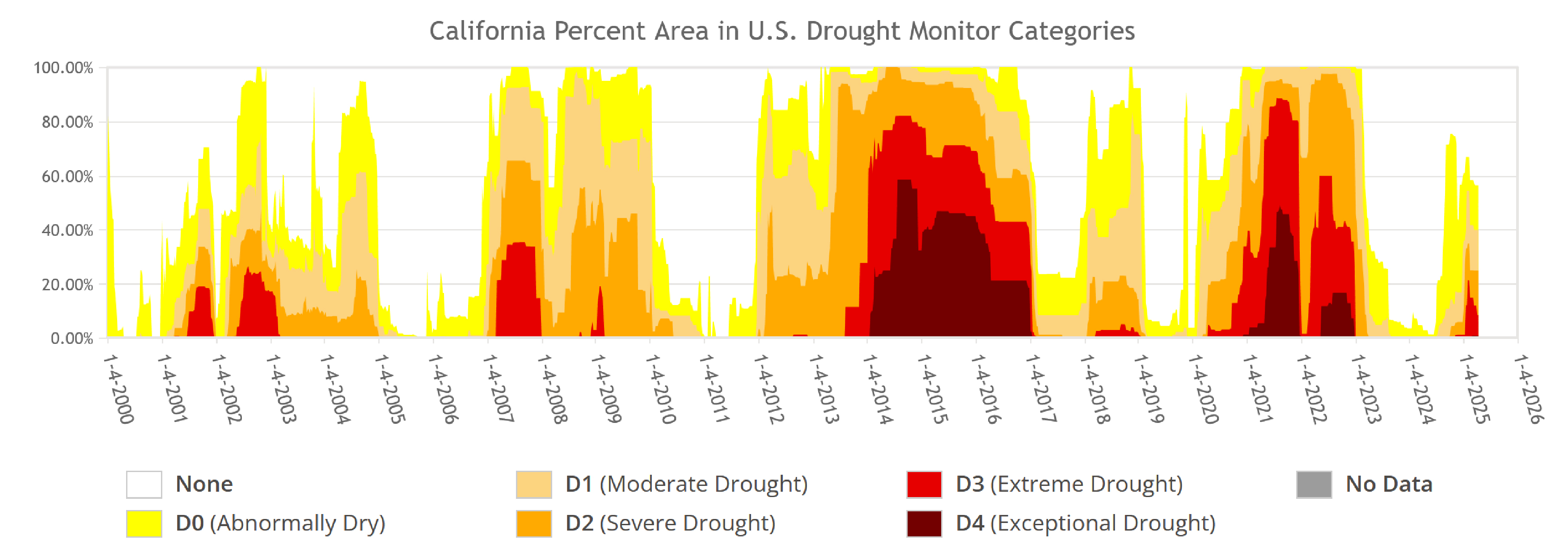
Figure 1. Time series of drought in California based on US Drought Monitor. The data show high levels of drought from 2012 – 2016 that ended in with flooding in Dec. 2016 – Jan. 2017 (atmospheric rivers) and drought also from 2002 – 2023 that ended in floods from atmospheric rivers. 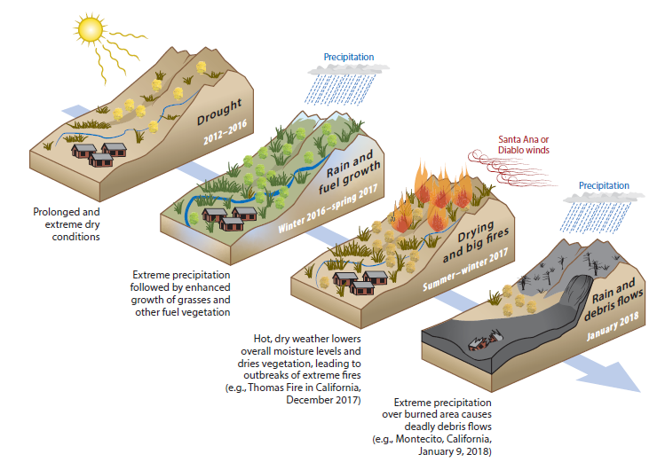
Figure 2: The above consecutive events resulted in substantial human health and economic impacts in Southern California: a prolonged extreme drought from 2012 to 2016; extreme precipitation during the winter of 2017 linked to atmospheric rivers, enhanced growth of shrubs and grasses, increasing fuel load; a very dry, warm spring and summer, reducing moisture levels and drying existing vegetation; record-setting Santa Ana winds (for sustained wind and low humidity); extreme fires occurring shortly thereafter (e.g., the Thomas Fire in December 2017); and extreme rainfall over the burned area in January 2018, leading to an extreme debris flow event in Montecito, CA. (AghaKouchak et al., Annual Reviews of Earth and Planetary Sciences, 2018). 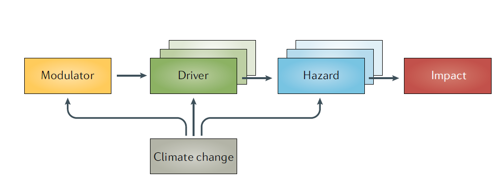
Figure 3. Elements of a compound weather and climate event (Zscheischler et al., NREE, 2020). 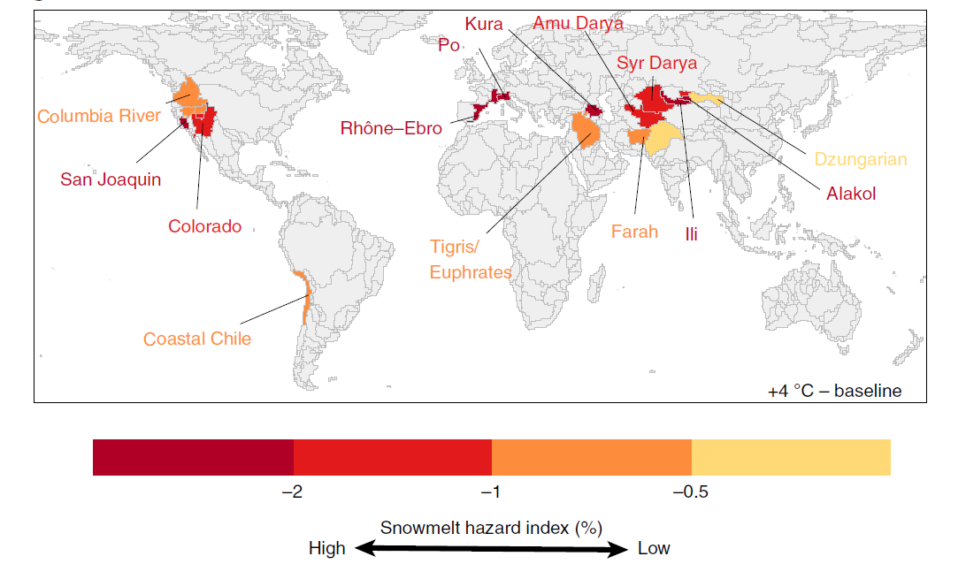
Figure 4. Basins at risk from changes in snowmelt under 4 °C warming (Qin et al., NCC, 2020).

