Listen here on Spotify | Listen here on Apple Podcast
Episode recorded on October 23, 2023
Episode released on March 7, 2024
 Marty Ralph is the Director for the Center for Western Weather and Water Extremes (CW3E) at Scripps Institute of Oceanography.
Highlights | Transcript
- A family of nine atmospheric rivers (ARs) hit California during a three-week period in late Dec. 2023 through Jan. 2024 resulting in flooding, ending an extreme meteorological drought (Fig. 1). They could see these ARs about 7 - 10 days ahead, providing forecast skill (DeFlorio et al., BAMS, 2023). On Jan 3 – 5th, they could see 5 ARs lined up in the forecast product. California is a land of extremes, droughts and floods, similar to Texas.
- To optimize water management within context of droughts and floods, Ralph and his team invented a program called Forecast Informed Reservoir Operations (FIRO) in 2014 and applied it to Lake Mendocino (capacity, 0.12 maf) on Russian River in 2016 (pilot).
- Prior to the 2022/2023 ARs, Lake Mendocino was at about 35% of capacity (~ 38,000 acre-feet, af)) and increased sharply to ~ 95,000 af related to ARs (Fig. 2). In late February, additional ARs were forecasted resulting in some water releases from the reservoir. FIRO allowed Sonoma Water Agency to store ~13% more water (~ 10,000 af) in Lake Mendocino going into summer 2023.
- Each reservoir is different in terms of purpose, size, climate, structure, and operations. Need to conduct individual studies to assess FIRO for each.
- FIRO was evaluated for Prado Dam (capacity, 0.31 maf) in southern California, in collaboration with US Army Corps of Engineers and Orange County Water District (OCWD), serving a population of ~20 million. Purpose of Prado Dam: flood control and also flood managed aquifer recharge. (link)
- Reservoirs operated by US Army Corps of Engineers (USACE) based on rules established several decades ago based on water on the ground (rain gauge, stream gage, and storage in reservoir or snowpack). USACE changed rules in 2015 to allow use of forecasts. USACE operates ~ 740 reservoirs in the US (link).
- There are privately operated reservoirs also that have been using forecasts in their operations.
- Frequency and strength of ARs generally determines whether California is in drought or flood because 5% wettest days (usually 5 – 10 d/yr) in California account for 8% of interannual rainfall variation.
- They are currently working on seven reservoirs: team, USACE, local water agency, National Weather Service (NWS) and Center for Western Weather and Water Extremes (CW3E, Ralph Director), steering committee, study goals (e.g., water supply reliability, flood risk mitigation, etc.,) developing road maps.
- Preliminary viability assessment: sufficient skill in forecasting precipitation and runoff to apply FIRO?
- Final viability assessment à water control manual update includes rules for reservoir operator, containing FIRO? (e.g., Final Viability Assessment for Lake Mendocino)
- Expanding FIRO: N California, Yuba (New Bullards Bar, capacity ~ 1 maf and Feather [Lake Oroville, capacity 3.5 maf] rivers come together downstream, fed by snow in Sierra Nevada Mountains (Yuba-Feather FIRO). Flood mitigation, new ARC spillway, 31.5 feet lower than existing spillway. These reservoirs ~ 10× larger than others studied. FIRO is also being evaluated for a reservoir in Seattle, for fisheries purpose, including salmon.
- A FIRO screening level process is being applied across all ~700 USACE reservoirs throughout US, excluding reservoirs without control structures (couple 100 reservoirs excluded).
- FIRO is being applied to a system of dams operating on single river system in coordinated way. Willamette in Oregon: 13 dams on tributaries to mainstem. FIRO on Seven Oaks dam on Santa Ana River, upstream of Prado Dam (link).
- FIRO on west coast reservoirs benefit from predictive skill of ARs. West coast rivers benefit from relatively short distances from reservoirs to coast and steep terrain, therefore, shorter lead times are sufficient for releases. FIRO more difficult to apply in flatter terrain with longer rivers.
- Globally ARs are found off W coast of Europe (Portugal hotbed), W coast of S America or part of Australia and New Zealand and S Africa and Middle East (Fig. 3) Family of ARs in E Australia Feb/Mar 2022
- Global ranking system for ARs: 1 – 5, like earthquake magnitudes based on AR strength and duration (Fig. 4) (Ralph et al., 2019)
- California extend analysis back 440 yr using dendrochronology, tree ring width linked to annual precipitation, essentially measuring ARs (Howard et al., 2023).
ARs and extreme events projected to become more critical in future with climate change, emphasizing importance of FIRO and other management approaches (Corringham et al., 2022).
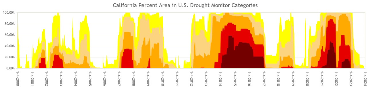
Figure 1. US Drought monitor time series for California showing abrupt end of meteorological drought in January 2017 and in January/February 2023 linked to atmospheric rivers (link). 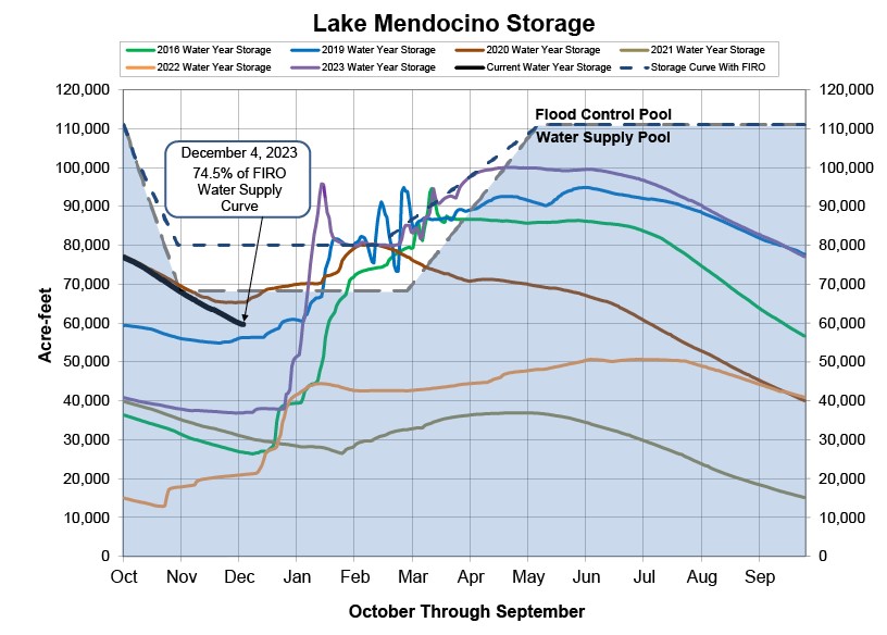
Figure 2. Lake Mendocino storage (link). Nine ARs increased storage from ~ 38,000 af to ~95,000 af. 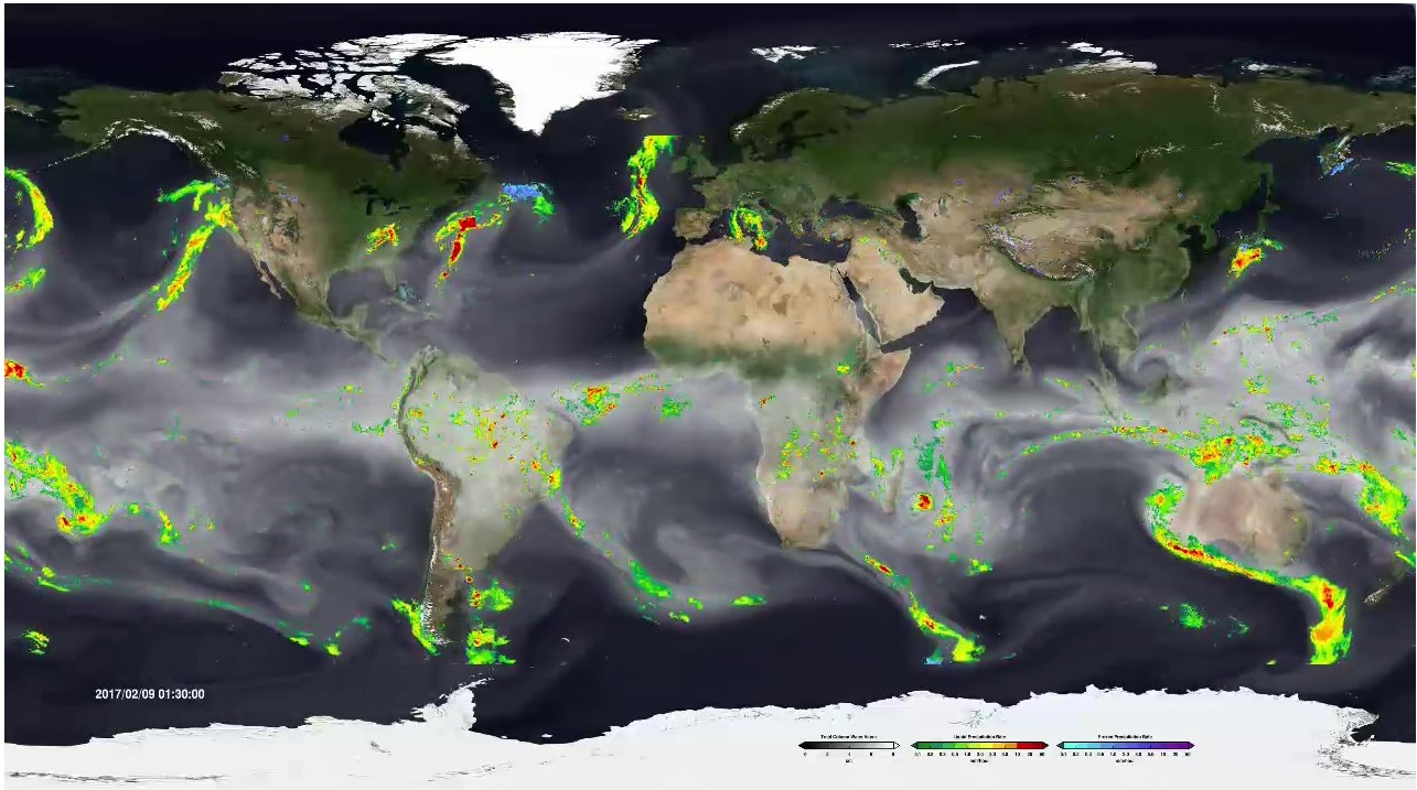
Figure 3. Global visualization of atmospheric rivers, February 2017 (link). 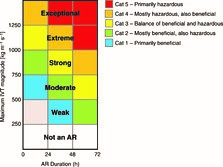
Figure 4. Scale for AR events based on maximum instantaneous integrated vapor transport (IVT) associated with period of AR conditions and duration of those conditions at a point (Ralph et al., 2019).

