Listen here on Spotify | Listen here on Apple Podcast
Episode released on April 20, 2023
 Lenny Konikow is the Editor-in-Chief of Groundwater journal and Emeritus Scientist with U.S. Geological Survey following 42-year career as a research hydrologist. His research focuses on groundwater – surface water interactions and local and global water budgets.
Highlights | Transcript
- Groundwater provides an opportunity to adapt to climate change as surface water resources are further depleted.
- Groundwater is a renewable resource in some regions but a fossil resource in other regions where it is being mined.
- The U.S. Geological Survey developed regional models of major aquifers in the U.S. within the Regional Aquifer System Analysis (RASA) program within the 1980s and 1990s.
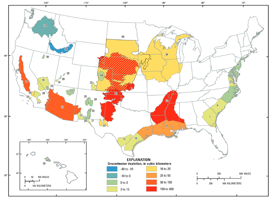
- Summing groundwater depletion over all major aquifers in the U.S. from 1900 – 2008 totaled about 1000 km3.
- Groundwater depletion is not uniformly distributed across the U.S., with most depletion in the High Plains and Central Valley aquifers.
- Net increases in groundwater storage were observed in the NW U.S. (Columbia and Snake River Plain aquifers) attributed to surface water irrigation (flood irrigation) recharging groundwater over many years.
- Groundwater and surface water are strongly connected and behave as a single resource.
- Expanding the analysis globally resulted in an estimated total depletion of 4,500 km3 over that period (1900 – 2008).
- Most groundwater pumped from aquifers ends up in surface water and the atmosphere and ultimately the oceans, contributing to sea level rise as a balance to depletion on the continents.
- Considering global groundwater depletion of 4,500 km2 and the area of oceans (361,000 km2) results in ~ 13 mm/yr sea level rise.
- The source of water pumped from aquifers was initially determined by C.V. Theis in the 1940s, mostly from aquifer storage during early stages of pumpage and ultimately capturing surface water from reduced discharge to streams and evapotranspiration.
- Groundwater pumpage is monitored in the U.S. Comparing groundwater pumpage with depletion indicates that 85% of pumpage is derived from capture with 15% derived from depletion of aquifer storage.
- GRACE satellites can be used to monitor total water storage, including surface water, soil moisture, and groundwater. The coarse resolution of GRACE data (~ 350 km) may not be highly appropriate for local and regional groundwater management.
- Discrepancies between groundwater depletion from regional groundwater modeling in the Mississippi Embayment Regional Aquifer System and GRACE satellite data is attributed to modeling issues related to inadequate representation of surface water and is currently being improved.
- The strong linkages between groundwater and surface water underscore the need to manage both conjunctively.