Listen here on Spotify | Listen here on Apple Podcast
Episode released on September 18, 2025
Episode recorded on June 16, 2025
 Randy Hanson discusses climate extremes in the Rio Conchos and the importance of conjunctively managing surface water and groundwater.
Randy Hanson is the President of One-Water Hydrologic, LLC and previously worked for the U.S. Geological Survey in San Diego for 38 years as a lead research hydrologist developing hydrologic models and water supply analysis of regional watersheds nationally and internationally. He is also winner of the 2025 John Hem Award from NGWA for excellence in science and engineering.
Highlights | Transcript
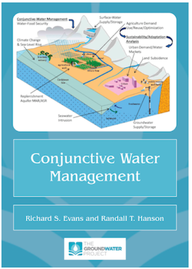
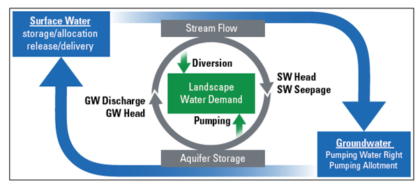
New book coming soon: Conjunctive Water Management (CWM) by Richard S. Evans and Randall T. Hanson (The Groundwater Project) (Fig. 1). This book describes the collective management via conjunctive water management of surface water, groundwater, precipitation, and recycled, imported, and reused water will require changes in governance. The book comes with 6 Model exercise scenarios to help students and practitioners learn how to use the One-Water model (MF-OWHM) to analyze CWM issues within a supply-and-demand framework to achieve sustainability.
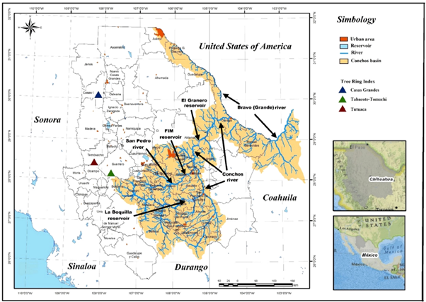
Rio Conchos (Fig. 2):
- Tributary of the Rio Grande, 74,000 km2 area, irrigation accounts for 95% of water use
- Paper titled "Capturing Wetness for Sustainability from Climate Variability and Change in the Rio Conchos, Chihuahua, Mexico"
- Mexico not meeting treaty deliveries to U.S.
- Emphasis on capturing water during wet climate cycles
- U.S. Mexico treaties:
- 1906 Water Treaty: US deliver 60,000 af/yr to the Rio Grande to the Acequia Madre diversion (known as the Old Mexican Canal) near the city of Juarez. This treaty considers “extraordinary drought impacts” on deliveries
- 1944 Binational Water Treaty: Mexico to deliver 1.75 maf of water over a sliding 5 yr cycle to US (Texas). Excess water beyond treaty requirements has been delivered many times by Mexico.
- Drought periods often 8 years and 1944 treaty should consider droughts. Sliding 5 yr cycle means that after MX meets treaty requirements during a wet period, it is reset for the next 5 yr cycle.
- Wet climate extremes are very important: evidence: Francisco Madero Reservoir on San Pedro River (tributary to the Rio Conchos), overflowed 26 times since it was built in the 1950s. (20 of overflows exceeded treaty deliveries)
- Extreme events include E Pacific hurricanes and tropical storms (4 in 2025 already)
- Sea surface temperatures (SSTs) increasing and more variable
- Intertropical Convergence Zone moving up and down latitudinally
- Mexico needs to capture excess water which exceeds MX treaty obligations for sustainability and conjunctive water management operations
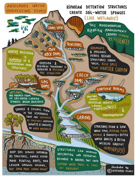
- Laura Norman (USGS) is working on an Aridland Water Harvesting Study using nature based solutions to mitigate flooding, drought, and erosion. They are capturing excess water from hurricanes in ranches outside La Paz in Baja Sur, Mexico. (Fig. 3)
- Land use changes: agricultural expansion, increasing perennial crops (pecan orchards), population growth in the Rio Conchos
- Climate Teleconnections:
- Standard Precipitation Index (SPI), 70 yr record: 57 months of v. wet to extremely wet conditions, 18 months sever to extremely severe dry conditions
- 26 overflows on Francisco Madera Reservoir: 8 during La Nina, 6 neutral, 11 El Nino: ENSO is important but not major driver as PDO and AMO are the major climate drivers.
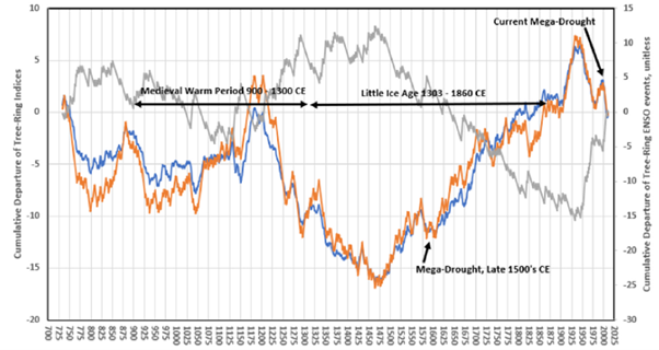
- Casas Grande tree rings extended to more than 1,000 yr ago (Earth Lab at Lamont Doherty) (Fig. 4)
- Casas Grande civilization had a water well (pre-Columbian civilization), only one in the Americas
- Linked tree ring width to category of ENSO cycle, extended ENSO to more than 1,000 yr ago
- Cave full of rabbit bones S of Tijuana: correlated rabbit bones with lake sediments in Ecuador, no ENSO for 5,000 yr after last Ice Age
- Pacific Decadal Oscillation (PDO), positive phase cooler wetter, opposite for negative phase
- Atlantic Multidecadal Oscillation (AMO) is the main driver of drought in North America and Northern Mexico
- Evaluate relationships between ENSO, PDO, and AMO and climate with implications for water resources and conjunctive water management
- Millennial solar oscillation: ~ 1,500 yr ago
- Extreme events include E Pacific hurricanes and tropical storms (4 in 2025 already)
- Drought periods: Rio Conchos: 1994, people drilled hundreds of groundwater wells
- Supreme Court lawsuit: increased groundwater pumping interfering with operating agreements between irrigation districts in Southern New Mexico.
California Central Valley
- Sustainable Groundwater Management Act:
- It is estimated that they will need to retire 800,000 acres to bring the Central Valley back to sustainability
- Economic impacts of droughts reduced because water markets allow water to move to higher value crops
- People drilling deeper and deeper wells and many shallow wells are going dry
- Groundwater depletion: leading to increased subsidence and salinity
- Drought periods, shift from predominantly surface water irrigation to groundwater-based irrigation during droughts
- Wild water: runoff on landscape before it becomes project water (agreements of distribution), approaches to capture wild water on the Rio Grande and Colorado Rivers
Rio Bravo (tributary to Rio Grande)
- Record pecan yields during last drought
Chile:
- Complete free water market, allowing mining companies and large agricultural entities to buy water rights, big issue and is being modified with new government oversight
One Water Hydrologic Model (Fig. 5)
- Supply and demand framework for modeling including surface water and groundwater
- MODFLOW Farm Package
- Reservoir operations: (Ian Ferguson, Bureau of Reclamation)
- One Water Hydrologic Model version of MODFLOW
- All MODFLOW codes are free
- Modeling can be used to test various adaptation strategies to increase sustainable management
- Managed Aquifer Recharge (chemical compatibility is important, Tucson, Arizona)
- Inefficient surface water irrigation recharges groundwater
- Rubber dams to enhance recharge in stream channels
- Hydroclimate Toolkit – Frequency analysis of time series and raster images of climate attributes and make projections