Listen here on Spotify | Listen here on Apple Podcast
Episode released on August 13, 2026
Episode recorded on April 9, 2026
 Matias Taucare discusses various challenges, including megadrought since 2010 and groundwater overexploitation in Chile since 1990.
Matias Taucare is an Assistant Professor at the Department of Geology at the University of Chile in Santiago. His research focuses mainly on mountain hydrogeology and also on water resource issues related to the impact of driving forces such as climate change and groundwater overexploitation of groundwater resources, using a variety of hydrogeochemical, geological, and geophysical tools.
Highlights | Transcript
Background (Physiography, Population, and Political Divisions)
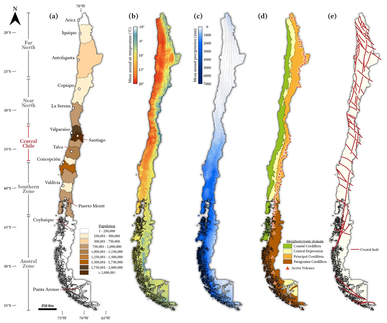
- The physiography of Chile is quite variable (Fig. 1a), impacting water resources.
Chile extends ~4,200 km north–south but is only ~200 km wide, creating major climatic and hydrologic contrasts. The area of Chile is ~750,000 km2, similar to that of Texas. The country includes the Andes (Principal) Cordillera (4–7 km elevation) separated from the Coastal Range (~2 km) by the Central Depression (sedimentary basin), similar to the Central Valley in California. California has the Sierras to the east and the Coastal Range to the west. The thickness of the aquifer in the Central Depression (300–500 m) is much less than the Central Valley (≤3 km) (Kang and Jackson, PNAS, 2016). - The population of Chile is ~18.5 million, with about half of the population located in Santiago in the central portion of the country. Chile has 16 political regions, such as Tarapaca Region (north), Antofagasta Region, Valparaiso Region, Metropolitan Region of Santiago, Los Lagos Region, Magallanes and Chilean Antarctica Region (far south) (Fig. 1b).
- Regions are subdivided into 56 provinces which are further divided into 346 communes.
Climate
- Climate varies from hyper-arid desert in the North (Atacama Desert) through Mediterranean type climate in central Chile (wet winters [austral winter] and dry summers) to humid glacier-fed systems in southern Chile.
- The Atacama Desert is the driest on the planet (~10 mm/yr of precipitation). In the North, the austral summer is humid with water vapor coming from the Amazon and the Atlantic influence.
- In central Chile, precipitation averages ~300 mm/yr in the Central Depression (Central Valley) up to 600 mm in the highest part of the Andes. There are glaciers in the highest part of the Andes feeding rivers into this region.
- Southern Chile is very humid, ~2000 mm/yr of precipitation in some areas, such as Valdivia.
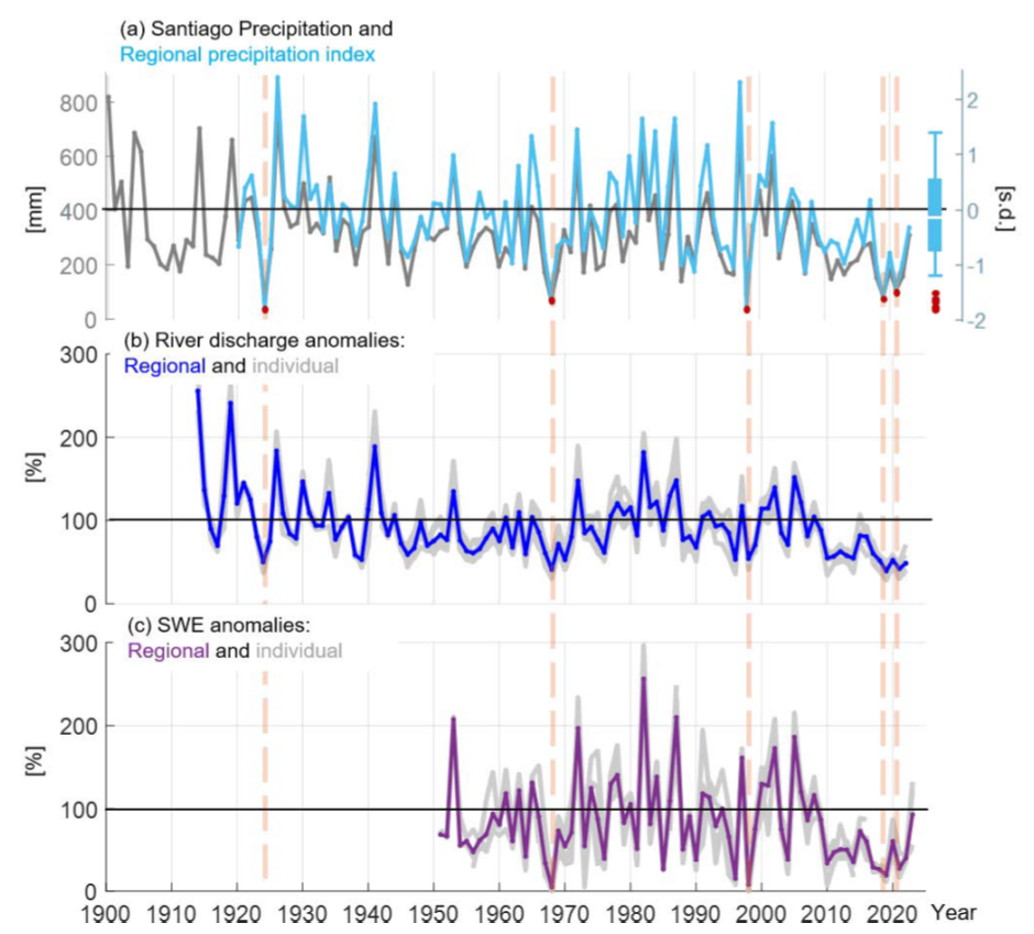
- Central Chile has experienced a megadrought since 2010 that has evolved into a hyperdrought (Garreaud et al., HESS, 2025). Rainfall reduced by 45% and by up to 75% in 2021 and 2022.
- Megadrought attributed to the Southern Blob or Southern Pacific Pressure trend dipole that is causing pressure ridging. Storm tracks are forced south towards Antarctica (Garreaud et al., JoC, 2021).
- El Nino Southern Oscillation is an important driver of precipitation in Chile, resulting in wet winters and dry summers.
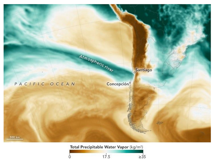
- Atmospheric rivers are also important in Chile, similar to California, linked to ENSO and winter precipitation (Fig. 3, Garreaud et al., Atmos., 2024).
Mining
- Mining is a dominant economic driver with a long history.
- Mining has evolved from silver and gold in central and northern Chile when the Spanish arrived in the 16th century.
- Nitrate (saltpeter) mining was dominant in the 1800s for fertilizers and explosives and was a dominant export product. The industry declined in the 20th century after the Germans invented the Haber Bosch process for synthetic nitrate production.
- Chile hosts some of the world’s largest copper porphyry deposits, mainly in the highest Andes open pit mine, such as Chuquicamata, Escondida, and Río Blanco-Los Bronces but also large underground mines, such as El Teniente. The Coastal Cordillera hosts Iron Oxide Copper Gold-IOCG deposits like the Candelaria mine and strata-bound-type deposits like Michilla mine, that were very important in the early Chilean copper production.
- Lithium has become very important in recent decades for the energy transition, especially batteries. Lithium concentrations in brines in Atacama salars exceeding 1000 mg/L and locally up to 7,000 mg/L (Munk et al., Chem Geol. 2018, Godfrey and Alvarez-Amado, Minerals, 2020). The Salar de Atacama contains some of the highest lithium concentrations in continental brines globally. The high concentrations are linked to long-term evaporation in a closed basin combined with volcanic and hydrothermal inputs from the Central Andes.
- There are disputes in the Atacama Desert related to lithium:
- Tourism (San Pedro de Atacama) (Jerez et al., Pol. Geog. 2021)
- Overexploitation of groundwater related to mining (Link et al., Water, 2025)
- Impacts on wetlands and ecosystems
Groundwater Overexploitation
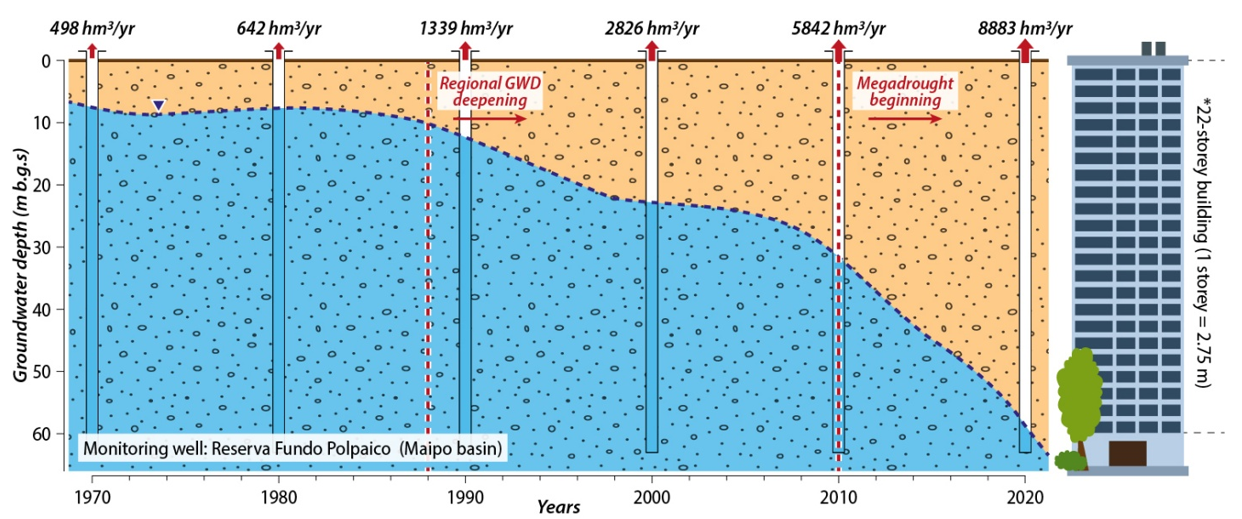
- Groundwater overexploitation is dominant in the Central Depression, 20–40 m/10 yr (2–4 m/yr) (Taucare et al., STOTEN, 2024).
- Some attribute groundwater depletion to the recent “megadrought” that has evolved into a prolonged “hyperdrought” since 2010.
- Since ~2010, central Chile has experienced persistent rainfall deficits, with major reductions in precipitation by 15–45% and streamflow. Water shortages have intensified pressure on groundwater systems.
- Groundwater depletion is not only climate-driven—it reflects decades of over-extraction.
Taucare emphasizes that aquifer declines predate the recent drought and began in the 1990s. Groundwater depletion accelerated during drought but was fundamentally linked to long-term over-allocation and pumping (Taucare et al., STOTEN, 2024). - Groundwater pumping increased from ~0.5 km3 in 1970 to 8.9 km3 in 2020 (Taucare et al., STOTEN, 2024).
- Groundwater depletion is causing broader environmental impacts:
- Disconnected rivers and wetlands,
- Ecosystem stress, and
- Land subsidence in parts of Santiago and surrounding regions.
- Basins without glacier recharge show the greatest declines (e.g., ~50 m groundwater declines over ~10 years in La Ligua Basin).
- The primary water user is agriculture, accounting for 77% of water use in 1970 and 63% in 2020 (Taucare et al., STOTEN, 2024).
- Horticultural products dominated, including avocados on the hills, vineyards, olives, and corn (Novoa et al., STOTEN, 2019).
Groundwater Recharge
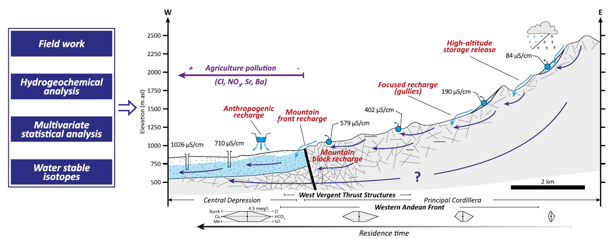
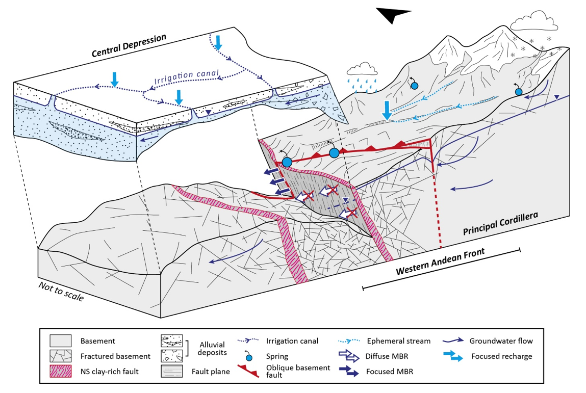
- Taucare’s research revised the conceptual model of recharge in central Chile (Fig. 5) (Taucare et al., STOTEN, 2020; Figueroa et al., STOTEN 2021).
Earlier models assumed mountains acted as impermeable boundaries. New hydrogeologic evidence shows groundwater moves through fractured volcanic rocks and faults, providing mountain-block and mountain-front recharge into valley aquifers. - Geochemistry and isotopes reveal multiple sources of recharge. Chemical tracers distinguish recharge pathways: irrigation return flows show higher sulfate and metal signatures, while mountain-derived groundwater tends to be more dilute and bicarbonate-rich. This work is now moving toward quantifying source contributions.
Water Governance and Water Markets
- Chile’s water governance relies heavily on water markets. Water rights established under the 1981 Water Code created transferable private rights governed largely by supply and demand.
- Water rights are a private property, separate from land ownership, granted by the government and freely traded. There are consumptive (irrigation, urban use) and non-consumptive (hydropower) water allocations.
- Water markets are most active in central Chile.
- Recent reforms introduced more restrictions and periodic review of rights due to increasing scarcity.
Energy
- Water is also important for energy production, especially hydropower, as exemplified by the Colbun hydroelectric station in central Chile.
- There is a lot of potential to develop geothermal energy as Chile lies in the Pacific Ring of Fire. Cerro Pabellon is the first large geothermal station in South America.
- Solar power is expanding in the Atacama Desert but is resulting in a lot of waste (chatarra).